The Atlantic Ocean is increasing in size
The Mid-Atlantic Ridge
The Mid-Atlantic Ridge is part of the global mid ocean ridge system. It is a divergent plate boundary where continental plates are moving apart. As the plates separate they are creating the Mid-Atlantic Ridge that separates the two continents. In the northern part of the ridge the Eurasian Plate is moving eastward and the North American Plate is moving westward.

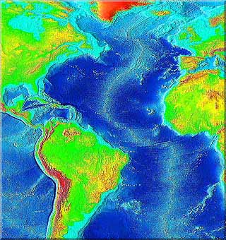
Mid-Atlantic Ridge runs down center of the Atlantic Ocean NOAA
Entire mid-atlantic ridge
The Mid-Atlantic Ridge is 16,000 km long. It is a curving path from the Arctic Ocean to the southern tip of Africa. The southern part of the Mid-Atlantic Ridge separates the African Plate and the South American Plate. The entire ridge extends from northeast of Greenland southward to the Gakkel Junction in the South Atlantic Ocean.
The entire global mid-ocean ridge system which is a continuous system of rift zones is 80,000 kilometers long. It is the largest geological feature on our planet and lies underwater except for a few islands.
Discovering the Mid-atlantic ridge
The HMS Challenger expedition in 1872 carried onboard three scientists that were studying the ocean floor because a transatlantic telegraph cable was going to be installed in the near future. The scientists discovered a large rise in the ocean floor during the expedition. Early in 1850 Matthew Fontaine Maury inferred there was a ridge in the middle of the Atlantic Ocean the HMS Challenger confirmed its existence during the 1872 expedition.

Our Earthquakes & Tsunamis is 97 pages long and includes fascinating facts about earthquakes and tsunamis. You will learn about the first earthquake detector, how earthquake's magnitude is determined and which earthquake waves travel in the body of the Earth in this book. Myrna Martin

Click for More Information and to Order
Mapping the ridge with sonar
The Mid-Atlantic Ridge was mapped by three scientists using sonar that had been developed during the World War II. They found rift zones that included valleys and ridges the entire length of the Atlantic Ocean. Running down the entire length to the Mid-Atlantic Ridge was a central valley where many earthquakes occurred. This discovery led to the general acceptance of Alfred Wegener’s theory of continental drift which became known as the Theory of Plate Tectonics.
Central rift valley
The highest point on the ridge is the central valley that runs down the center of the Mid Atlantic Ridge. It lies about 2,500 meters (8,200 feet) below sea level. The edges of the bulging seafloor drops down below sea level on its flanks 5,000 meters. Magma erupting on the seafloor in the central valley creates the newest crust on the surface of the Earth.

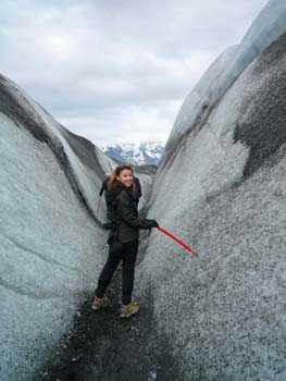
Walking on the Mid-Atlantic Ridge in Iceland Sarah Masters
Iceland lies on the ridge
Iceland lies on the northern part of the Mid-Atlantic Ridge. It has formed over both the ridge and a hot spot. Iceland on the western side is part of the North American Plane and on the eastern side lies the Eurasian Plate. The Thingvellir Rift Valley on Iceland is about 10,000 years old where the plates are separating.
Thingvellir Rift Valley
The Thingvellir Rift Valley has widened 70 meters (230 feet) and sunk 40 meters (131 feet during the last 10,000 years). Volcanoes have erupted creating new land on the island as the continents drift apart. Fifteen volcanoes have erupted on Iceland in the past 100 years.
KIDS FUN Science Bookstore
Check out Myrna Martin's award winning textbooks, e-books, videos and rock sets. The Kids Fun Science Bookstore covers a wide range of earth science topics. Click here to browse.


