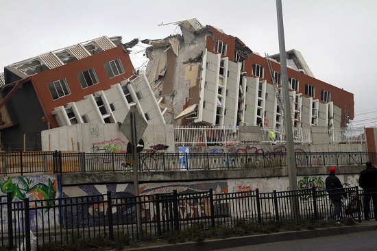
2010 Chilean Earthquake
Chilean earthquake on Feb. 27, 2010
The Chilean earthquake occurred on February 27, 2010. It registered 8.8 on the moment magnitude scale. The earthquake was caused by the Nazca and South American Plates converging. Thrust-faulting by the South American Plate as it overrides the Nazca Plate created the megathrust earthquake.

2010 Earthquake in Chile by Claudio Nunez
Fault line ruptured
Length of fault line rupture
The rocks ruptured along the fault line for about 695 km (430 miles). The rocks moved 9 m (30 feet) during the earthquake. It was the strongest quake to hit the region since the Chilean Valparaiso earthquake in 1960. That earthquake registered 9.5 on the moment magnitude scale and is the largest ever recorded on seismographs.
Movement of Conception, Chile
GPS data indicated that the entire city of Conception, Chile moved westward 3 m (10 feet). The country's capital, Santiago, moved 25 cm (10 inches) westward. Waves in Lake Pontchartrain just north of New Orleans were caused by the earthquake 7565 km (4,700 miles) away.


Click for More Information and to Order
80% People felt severe shanking
More powerful than Haitian earthquake
Eighty percent of the people living in Chile experienced severe shaking. The earthquake is estimated to be between 300 and 500 times more powerful than the Haitian earthquake. Chile has strict earthquake building codes that saved many people's lives.
Falling buildings deadly during an earthquake
There is a saying about earthquakes. Buildings kill people not earthquakes. Even so, the earthquake was so powerful it damaged 370,000 homes and 486 people died. It was the strongest earthquake worldwide since the 2004 Indian Ocean Earthquake.
KIDS FUN Science Bookstore
Check out Myrna Martin's award winning textbooks, e-books, videos and rock sets. The Kids Fun Science Bookstore covers a wide range of earth science topics. Click here to browse.


