Cascadia Subduction Zone Great Quakes
Location of cascadia Subduction Zone (CSZ)
Trench is 50 miles offshore
The Cascadia Subduction Zone lies 50 miles off the coast of southwest British Columbia, Washington, Oregon and Northern California. It formed as the ocean crust of the Juan de Fuca Plate, subducts beneath the North American Plate. The fault runs about 50 miles offshore for 1094 kilometers (680 miles). The plates are locked and strain is building in the rocks.
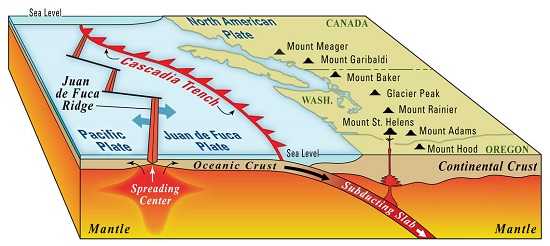
Major features of the Cascadia Subduction Zone USGS
Last great Earthquake
Great earthquake on January 26, 1700
The last great Cascadia earthquake happened over 300 years ago. Records of the event were not written down but researchers have discovered through evidence in peat bogs, tree rings and Japanese tide records of a tsunami when the event occured and the time based on the speed of tsunamis.
Megathrust earthquake
Today scientists believe a megathrust earthquake occurred on January 26, 1700 at 9:00 pm. The fault broke along 1000 kilometers (620 miles) and produced an earthquake with a magnitude between 8.7 and 9.2 on the moment magnitude scale. Scientists believe another megathrust earthquake could happen at anytime sending tsunamis onto coastal areas.

Click for More Information and to Order
The Cascade Volcanoes
Formation of Cascade Range
Towering volcanoes have formed on the continental side of the fault zone. Mount Rainier, Mount Saint Helens, Mount Hood, Mount Mazama and Mount Lassen are some of the volcanoes that make up the Cascade Range. These volcanoes have erupted in the not too distant past.
Mount Saint Helens
Mount Saint Helens is one of the most active in the Cascade Volcanic Arc. It erupted in 1980 with a massive eruption that formed a caldera in the summit. Today a lava dome is growing in the caldera and the area around the volcano has been declared a national monument.
KIDS FUN Science Bookstore
Check out Myrna Martin's award winning textbooks, e-books, videos and rock sets. The Kids Fun Science Bookstore covers a wide range of earth science topics. Click here to browse.


